Road Safety Optimization Through Video Analysis of Risky Behavior
Only 36% of French people today consider road sharing to be good, compared to 45% in 2023 and 50% in 2022. This declining perception shows that road safety and user coexistence have become priorities in rethinking our infrastructures.
The collection and analysis of behavioral data on the roads help better understand risky practices and optimize traffic management and user safety. The minUi tool, based on video analysis, provides detailed data to help understand these phenomena. Here’s how.
Reading time : 7min
Lane splitting: securing dense traffic
Lane splitting, where powered or unpowered two-wheelers travel between lanes of cars, is common in large cities. However, this practice—often tolerated but poorly regulated[1]—carries many risks: collisions, lack of visibility, unpredictable behavior by other drivers, etc. Local authorities struggle to assess this behavior due to a lack of reliable data and precise behavioral analysis. The challenge is to better understand where, how, and under what conditions this practice becomes dangerous.
[1] An experiment is underway in 21 French departments for lane splitting by powered two-wheelers. https://www.service-public.fr/particuliers/actualites/A15077
minUi enables precise analysis of lane-splitting patterns through the study of vehicle flows, distinguishing by mode. By identifying trajectories, risky behavior, and locations where accidents are likely to occur, minUi provides objective data. This information can be used by local authorities to adapt signage, review lane layout, and potentially better regulate lane splitting in road safety policies.
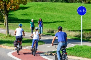
Helmet use and distractions: improving safety for vulnerable users
Helmet use, although recommended (and mandatory for children under 12) for cyclists and scooter users, is not always followed. Furthermore, the use of distractions like mobile phones, which is prohibited by the traffic code, increases accident risks. Study managers often lack tools to assess the extent of these risky behaviors.
minUi’s video analysis capabilities automatically detect soft modes and isolate them for in-depth analysis. This allows for semi-supervised categorization of users with or without helmets, using distractions, or riding two on a bike or scooter…
These data, collected over extended periods, provide study managers and decision-makers with a better understanding of risky behavior in different areas (bike lanes, shared roads, etc.), helping them prioritize prevention actions and evaluate the effectiveness of implemented measures.
Dangerous pedestrian crossings: targeting high-risk areas
Crossing streets outside designated crosswalks, often referred to as “jaywalking,” poses a constant danger, particularly in dense urban areas. Pedestrians distracted by electronic devices or simply ignoring rules, poorly designed infrastructure, or insufficiently marked crossings all contribute to these dangerous situations. Local authorities often lack reliable data to identify high-risk zones and intervene proactively.
MinUi, through video processing, automatically highlights areas where pedestrian crossings are frequent, thanks to user trajectories. These data allow municipalities to target zones needing improvements (additional signage, crosswalk installation) and optimize urban planning.
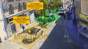
Illegal parking: reducing its impact on safety and traffic flow
Illegal parking—especially in sensitive areas like intersections, emergency lanes, or near schools—causes disruptions and can quickly become hazardous. By obstructing visibility or blocking critical traffic lanes, these violations endanger pedestrians and cyclists while worsening congestion.
Yet it is often difficult for authorities to effectively monitor these zones in real time or retroactively, and to precisely measure the scale of the issue.
MinUi automatically detects vehicles in violation in specific zones (intersections, schools, etc.). The tool generates occupancy statistics, time spent in the area, and can also trigger real-time alerts. By analyzing parking behavior, minUi provides actionable data on the frequency of violations and critical zones. This enables local authorities to intervene in a targeted manner—whether by increasing enforcement or evaluating infrastructure changes.
Conclusion and perspectives
Making cities safer means encouraging active modes of transport and decarbonizing mobility. Having the data and tools to precisely identify risky behavior is essential to making informed decisions and reducing accidents. minUi offers a reliable solution by providing indicators on practices such as lane splitting, helmet use, dangerous pedestrian crossings, and illegal parking.
The Ministry of the Interior, in collaboration with Cerema, uses minUi-generated measurements to feed the National Interministerial Road Safety Observatory (ONISR) with valuable statistics on risky behaviors and to guide future decisions.